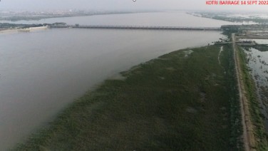
Background : Kotri Barrage, also known as Ghulam Muhammad Barrage, is a gate-controlled structure across the Indus River near Hyderabad, Sindh. Construction began in January 1950 and the project was completed and formally inaugurated in March 1955 by the then Governor-General of Pakistan, Ghulam Muhammad, after whom the barrage is named. The barrage was required to ensure a reliable irrigation supply to the vast canal network of lower Sindh, to safeguard against uncontrolled seasonal floods of the Indus, and to check seawater intrusion in the deltaic region.
It provides controlled water distribution to the Fuleli, Pinyari, Kalri-Baghar Feeder and Akram Wah canal, with a combined summer canal discharge exceeding 41,000 cusecs. The siting and principal technical decisions were made under the leadership of Chief Engineer T. A. W. Foy, who supervised construction and introduced important design modifications, including the final alignment and method of construction. The Central Engineering Bureau of the Government of Pakistan, with technical input from international consultants such as Harza Engineering Company (U.S.), prepared the detailed designs.
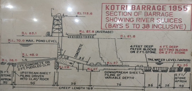
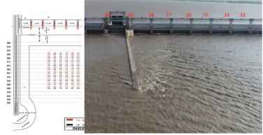
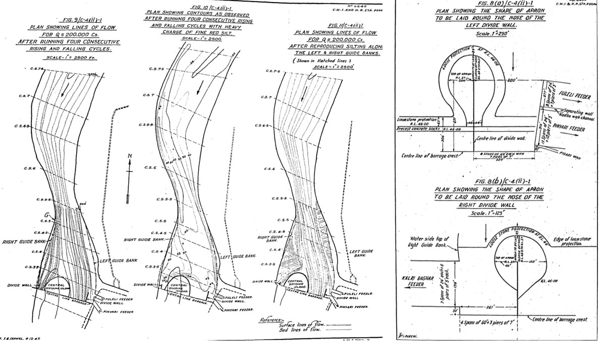
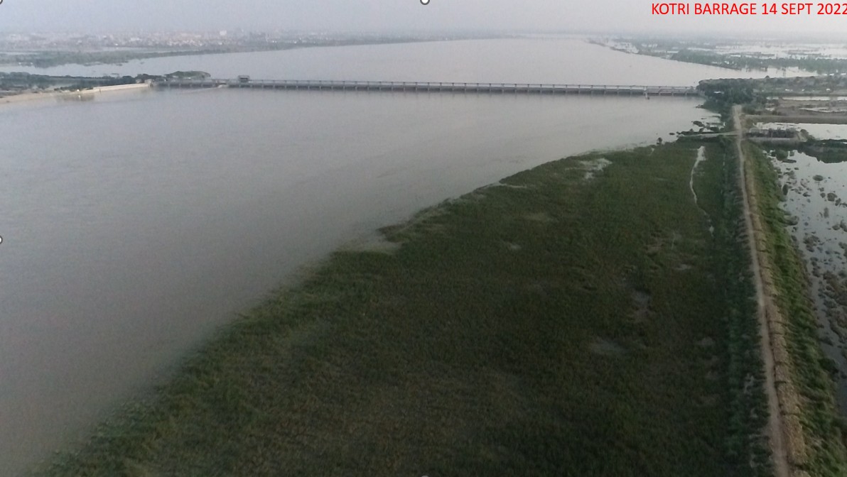
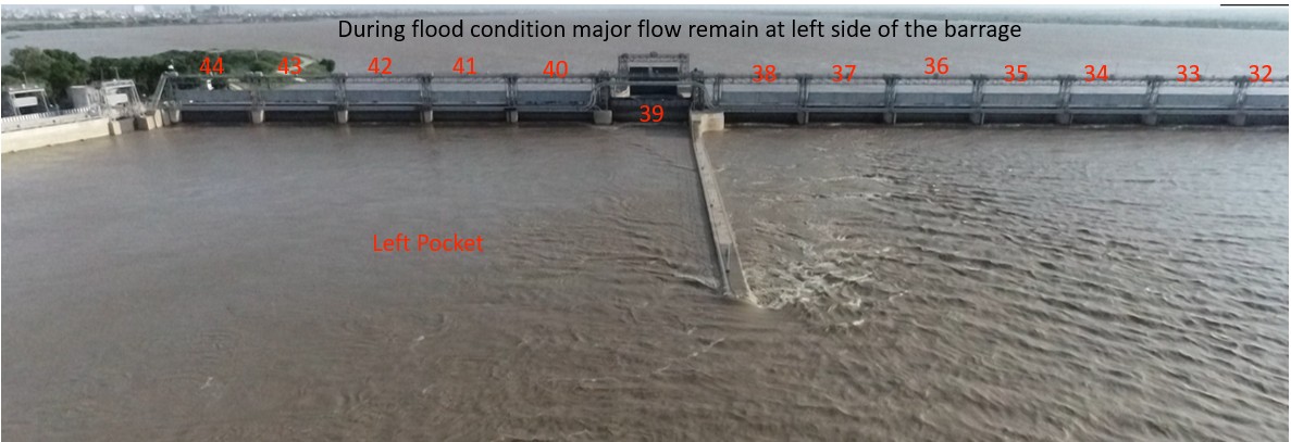
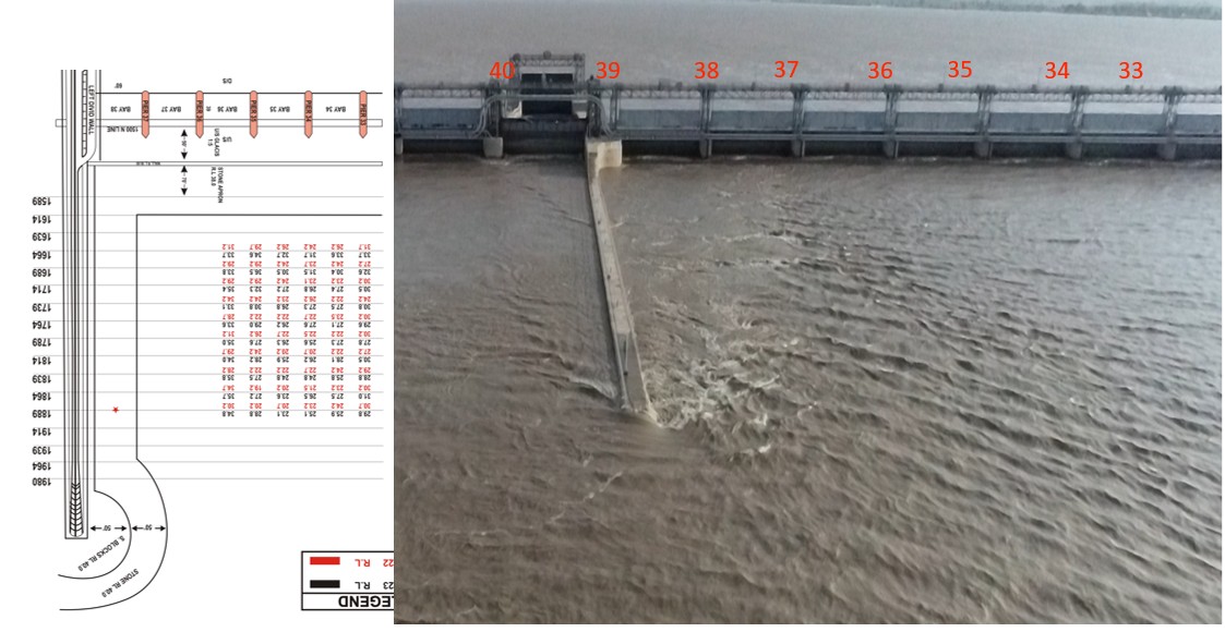
The structure was executed under the Irrigation & Public Works Department of Sindh. The barrage is 2,984 feet long, with 44 bays each 60 feet wide, and has a design discharge capacity of 875,000 cusecs. A record flood of 981,000 cusecs was successfully passed in 1956. The works also include a navigation lock, two fish ladders, and extensive training banks.
The barrage gates and mechanical equipment were procured through international suppliers of the time (records indicate British manufacturers such as Rapier Ltd were involved in gate fabrication and supply). Subsequent rehabilitation phases in 1989–2000 involved installation of 94 piezometers, gate replacement and raising, widening of the roadway, strengthening of pavement and raising of pond level from RL 68.0 to RL 70.0, ensuring continued safe operation. Today, Kotri Barrage remains the last barrage on the Indus within Sindh and a lifeline for agriculture, flood control and socio-economic development of the province.

|
|
||
| I. | Barrage Construction Started | Jan 1950 by |
| II. | Barrage Completed / Commissioned | Mar 1955 |
| Total Cost of Project | Rs. 935.0 Million | |
| III. | Barrage Designed Discharge | 875,000 CUSECS |
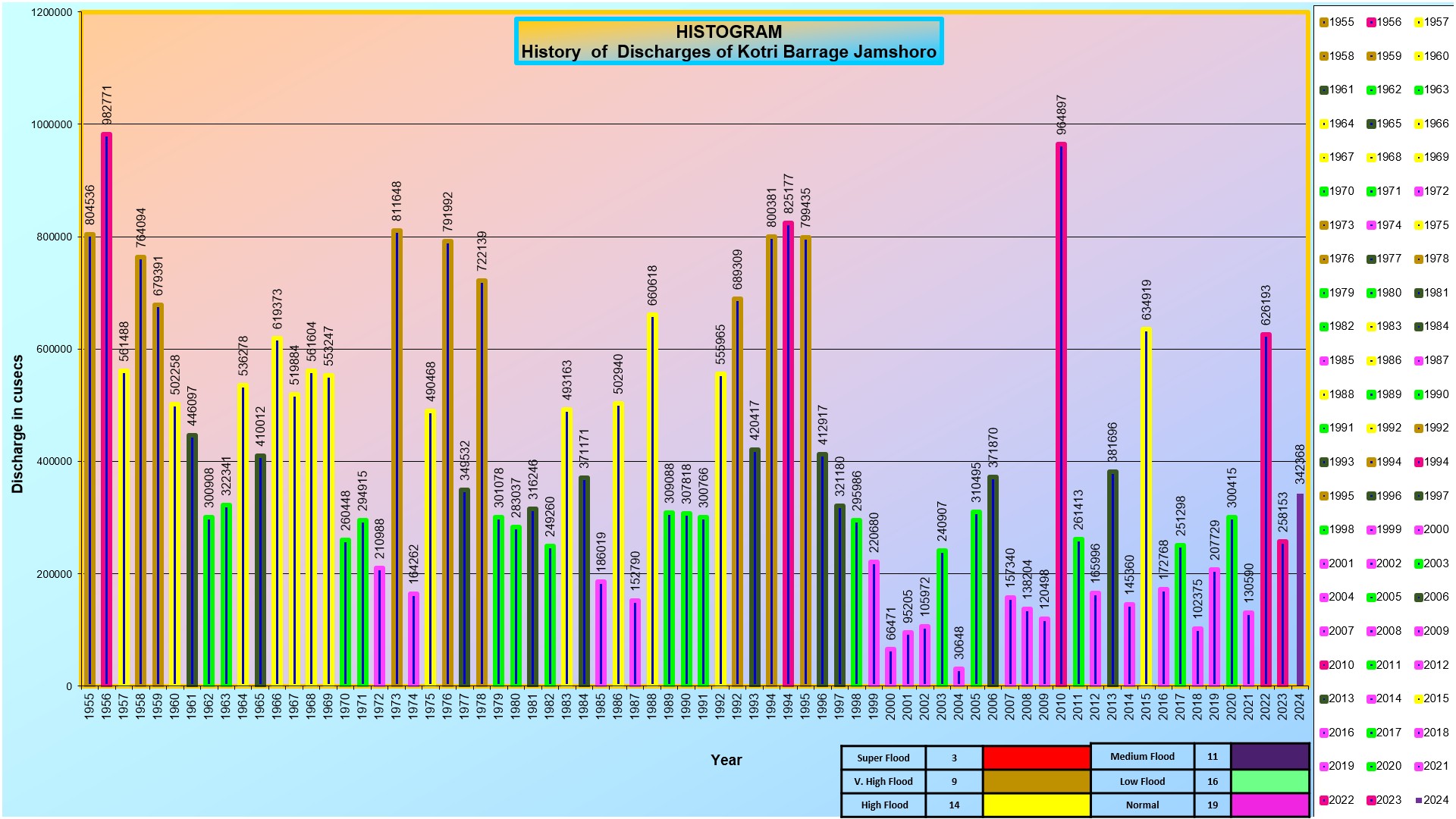
| IV. | Max Flood Discharge Passed in 1956 | 981,000 CUSECS |
| Max Flood Discharge Passed in 2010 | 9,64,897 Cusecs | |
| V. | Crest Level of Scouring Sluices | 176.0 |
| VI. | Summery Discharge of Off-Taking Canals | 41,230 CUSECS |
| VII. | Designed Discharge of Fuleli Canal | 14,350 CUSECS |
| VIII. | Designed Discharge of Pinyari Canal | 13,800 CUSECS |
| IX. | Designed Discharge of Kalri Baghar Feeder | 9,100 CUSECS |
| X. | Designed Discharge of Lined Channel | 4,100 CUSECS |
| XI. | Length of Barrage Between Abutments | 2,984 ft |
| XII. | Total Number of Gates | 44 Nos |
| XIII. | Width of Each Span | 60 ft |
| XIV. | Number of Navigational Lock Channels | 1 No. |
| XV. | Number of Fish Ladders | 2 Nos. |
| XVI. | Width of Ordinary Pier of Barrage | 7 ft |
| XVII. | Height of River Gate | 23 ft |
| XVIII. | Weight of River Gate | 44 TONNES |
| XIX. | Weight of Counterweight | 88 TONNES |
| XX. | Designed Upstream Flood Level | 80.10 ft |
| XX. | Pond Level (Normal) | 68.0 ft |
| XXI. | Pond Level (After Rehabilitation) | 70.0 ft |
| XXII. | Crest Level | 48.0 ft |
| XXIII. | Downstream Pavement Level | 37.0 ft |
| XXIV. | Upstream Pavement Level | 40.0 ft |
| XXV. | Up Stream Stone Apron of Barrage | R.L 38 & 5 ft depth with 35ft Length U/s |
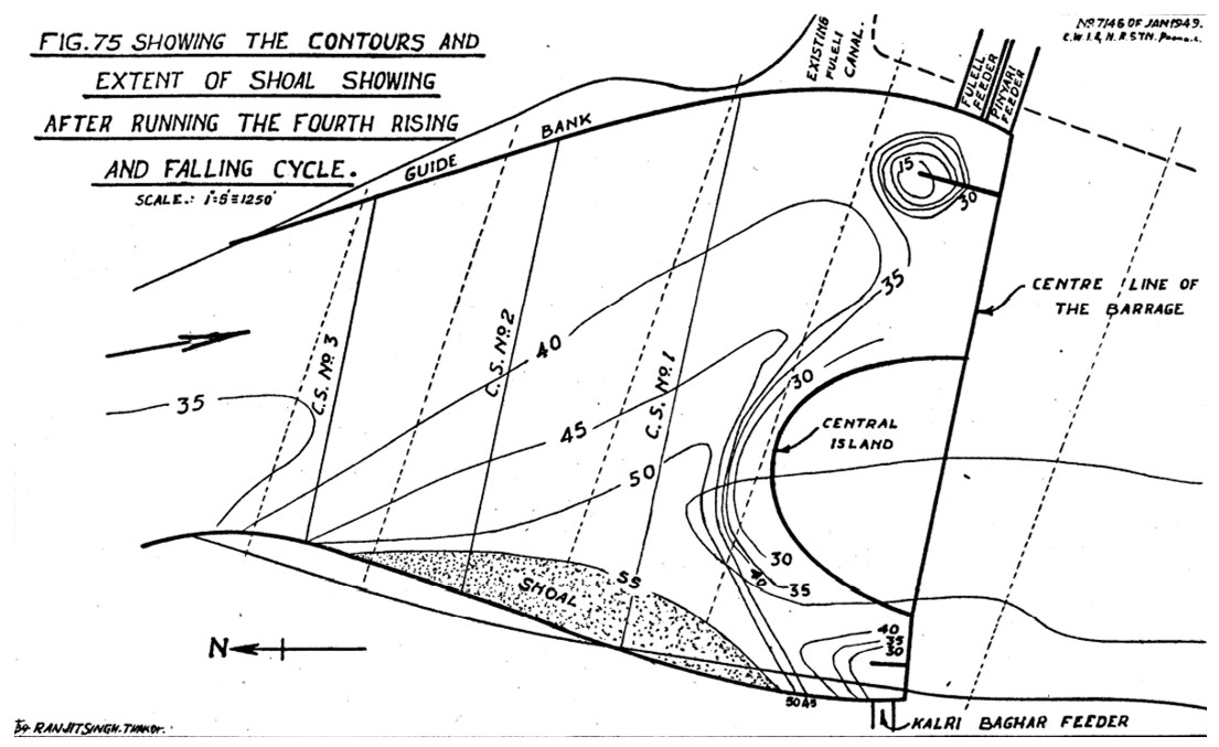
| XXV. | Divide Walls (2 Nos) |
Right Side: Us-361.5 , Ds-351.5ft total=RDW 713 ft |
|
Left Side: Us-561.6 , Ds-351.5ft Total=LDW 913 ft |
||
In 1987 Overseas Development Administration(ODA) prearranged the British consultant M/S Coode Bilzard Ltd. to perform a study to recover and constraints of Kotri Barrage to overcome the problem.
Up-Lift Pressure which subsist beneath pavement and glacis.
Pulsation of metal thickness of barrage’s gates.
Weakening of Barrage Road way.
Head limitation and resulting shortage of water supply to off-taking canals especially in Rabi season.
In 1989, after completion of study, scheme of works were recommended in different phases.
Installation of Piezometers.
Replacement of Gates.
Widening of Roadway.
Increase of pavement thickness to 2’ for deletion of head limitation.
By the grace of God, after completion of the Project, Kotri Barrage has become a Model Barrage on Indus.
Head Works positioned to model criterion.
Pond Level increases to R.L 68 to R.L 70.
Facility of a floating workshop Pontoon .
|
|
||
| I. | Rehabilitation Works Started: | November 1989 |
| II. | Rehabilitation Works Completed: | June 2000 |
INSTALLATION OF 94 PIEZOMETERS |
||
Work Carried Out During Phase I |
||
| 82 on Main Barrage & 12 on Head Regulators to check uplift pressure | ||
Works Carried Out During Phase II |
||
| i) | Replacement of Main Barrage as well as Canal Gates & height of Main Barrage Gates raised from 21 FT. to 23 FT. | |
| ii) | Thickness of road slab increased 5 to 10" | |
| iii) | Widening of roadway from 20 FT. to 24 FT. | |
Works Carried Out During Phase III |
||
| i) | Under water concrete to raise D/S pavement by 2 FT: from R.L 35 to R.L 37 | |
| ii) | Removal of head limitation from 24 FT. to 32.0 FT. Cut off | |
| iii) | U/S pond level raised from R.L 68.0 to R.L 70.0 | |

| Canal System | Unit | Pinyari Canal | Kalri Baghar | Fuleli Canal | Akram Wah |
|---|---|---|---|---|---|
| Length of Main Canals | Mile | 56.5 | 58.4 | 59.8 | 76.2 |
| G.C.A | Acres | 778,281 | 708,886 | 1,022,448 | 566,065 |
| C.C.A | Acres | 768,076 | 683,652 | 971,823 | 546,418 |
| Discharge (Kharif) | Cusecs | 13,636 | 9,100 | 15,026 | 3,714 |
| Discharge (Rabi) | Cusecs | - | 3,300 | - | 1,900 |
| Total Length of Channels | Mile | 828 | 851 | 800 | 481 |
| Design Discharge | 9100 Cusecs |
| Full Supply Level | 67.0 Ft |
| Full Supply Depth | 15.0 Ft |
| Design Bed Level | 52.0 Ft |
| Design Bed Width | 195 Ft |
| Nos. of Span | 6.0 Nos. |
| Width of Span | 24.0 Ft |
| CCA | 603000 Acres |
| Length of Canal | 38.0 Miles |
| Cutoff | 13.80 Ft |
| Pavement Level | 52.0 Ft |
| Cill level | 56.0 Ft |
| Design Discharge | 28,223 Cusecs |
| Full Supply Level | 67.0 R.L |
| Full Supply Depth | 15.0 Ft |
| Design Bed Level | 52.0 R.L |
| Design Bed Width | 346 Ft |
| Nos. of Span | 12.0 Nos. |
| Width of Span | 24.0 Ft |
| Length of Canal | 4.0 RDs |
| Cutoff | 13.10 Ft |
| Pavement Level | 47.50 R.L |
| Cill level | 56.0 R.L |
| Height Of Gates | 10.50 Ft |
| Design Discharge | 4100 Cusecs |
| Full Supply Level | 67.0 R.L |
| Full Supply Depth | 15.0 Ft |
| Design Bed Level | 52.0 R.L |
| Design Bed Width | 50 Ft |
| Nos. of Span | 02.0 Nos. |
| Width of Span | 24.0 Ft |
| Length of Canal | 80 Miles |
| Cutoff | 16.10 Ft |
| Pavement Level | 50. R.L |
| Cill level | 56.0 R.L |
| Height Of Gates | 10.50 Ft |
| Design Discharge | 13800 Cusecs |
| Full Supply Level | 65.30 R.L |
| Full Supply Depth | 19.50 Ft |
| Design Bed Level | 45.80 R.L |
| Design Bed Width | 211. Ft |
| Nos. of Span | 09.0 Nos. |
| Width of Span | 15.0 Ft |
| Length of Canal | 561/8 Miles |
| Cutoff | 5.0 Ft |
| Pavement Level | 45.80 R.L |
| Cill level | 45.80 R.L |
| Height Of Gates | 12.50 Ft |
| Design Discharge | 14350 Cusecs |
| Full Supply Level | 67.0 R.L |
| Full Supply Depth | 15.2 Ft |
| Design Bed Level | 51.80 R.L |
| Design Bed Width | 255. Ft |
| Nos. of Span | 07.0 Nos. |
| Width of Span | 24.0 Ft |
| Length of Canal | 81.33 Miles |
| Cutoff | 7.0 Ft |
| Pavement Level | 49.33 R.L |
| Cill level | 54.60 R.L |
| Height Of Gates | 10.50 Ft |
Kotri Barrage Region


Kotri Barrage Region
| KB Feeder | Pinyari Feeder Canal | Total | |||
Irrigation Channels Details |
|||||
| Main Canal | 03 | 01 | 04 | ||
| Branch | 03 | 10 | 13 | ||
| Distributaries | 43 | 40 | 83 | ||
| Minors | 56 | 64 | 120 | ||
| Total | 105 | 115 | 220 | ||
Detail of CANALS. |
|||||
| Total Length of Channels (Miles) | 828 | 851 | 1679 | ||
| GCA ( M-Acres ) | 0.892 | 0.709 | 1.601 | ||
| CCA M-Acres | 0.882 | 0.684 | 1.566 | ||
| Designed Discharge (Cusecs) | 9100 | 13800 | 22900 | ||
| No of outlet | 2586 | 3366 | 5952 | ||
Kotri Barrage was commissioned in 1955.* 04 Nos. Main Canals are off-taking from this Barrage, one from right bank namely, "Kalri Baghar Feeder" and 03 from left bank namely (i) Old Fuleli (Pinyari Feeder) (ii) Fuleli Canal and (iii) Akram Wah.* 02 Nos. Main Canals have been transferred to SIDA i.e. Fuleli Canal and Akram Wah. * Total CCA of Kotri Barrage is 3,083,704 acres. * CCA of Canals Under Kotri Barrage Region is 1,565, 463 acres. |
|||||
Kotri Barrage Left Bank Region
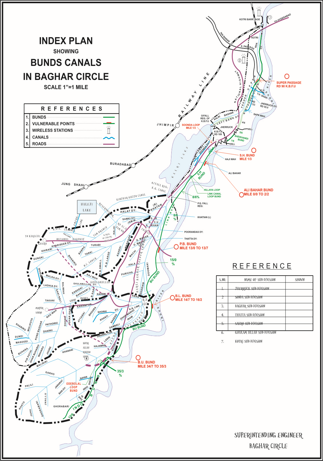
Salient Features of Bunds |
||||
| Division | First Line Bund | Second Line Bund | Total Length (Miles) | SPURS |
| BAGHAR CIRCLE HYDERABAD (Right Side) | ||||
| KALRI BAGHAR DIVISION THATTA | 74-3+22 | 10-2 |
1st Line : 115-4 2nd Line : 10-2 |
- |
| SAKRO DIVISION MIRPURSAKRO | 41-1 | - | ||
| PINYARI CIRCLE HYDERABAD (Left Side) | ||||
| UPPER PINYARI DIVISION HYDERABAD | 45-1 | 26-4 |
1st Line : 107-4+300 2nd Line : 26-4 |
09 Nos. |
| LOWER PINYARI DIVISION SUJAWAL | 62-3+300 | 26-4 | ||
Kotri Barrage Region Total |
|||
| First Line Bund | Second Line Bund | Net Total of Main & Loop Bund | |
| 223+520 | 36-6+300 | 259-7+160 Mile | |
HYDRAULIC DATA OF BAGHAR CIRCLE, HYDERABAD |
||||
| Kotri Barrage Division, Jamshoro | Kalri Baghar Division, Thatta | Sakro Division, Mirpursakro | Grand Total | |
| Nos. of Channels | 10 | 24 | 79 | 113 |
| Length of Channels (Miles) | 56.3 | 242.43 | 548.9 | 847.63 |
| Regulators | - | 32 | 115 | 147 |
| Bridges | - | 36 | 111 | 147 |
| Escapes | - | 2 | 1 | 3 |
| Modules | 139 | 552 | 2093 | 2784 |
| Cross Drainage | - | 39 | - | 39 |
| Pumping Machines | 8 | KBFU 256 | Kotri Mr. 06 | 8 |
| G.C.A (Acres) | 52298 | 107046 | 612917 | 772271 |
| C.C.A (Acres) | 48159 | 102694 | 580959 | 731823 |
| Design Intensity (Kharif) | 33% | 33% | 33% | 99% |
| Design Intensity (Rabi) | 40% | 40% | 40% | 120% |
| Cultivation Kharif (Acres) | 7869 | 35998 | 100659 | 144526 |
| % Age Kharif | 16% | 35% | 17% | 58% |
| Cultivation Rabi (Acres) | 15522 | 27788 | 79908 | 123218 |
| % Age Rabi | 32% | 27% | 14% | 73% |
PERENNIAL / NON‑PERENNIAL |
||||||||||||||||
| S.NO. | Name of Division | Perennial | Non‑Perennial | |||||||||||||
| 1 | Kotri Barrage Division, Jamshoro | --- | 52298 | |||||||||||||
| 2 | Kalri Baghar Division, Thatta | 86468 | 8794 | |||||||||||||
| 3 | Sakro Division, Mirpursakro | 274298 | 240293 | |||||||||||||
| Grand Total | 360766 | 301385 | ||||||||||||||

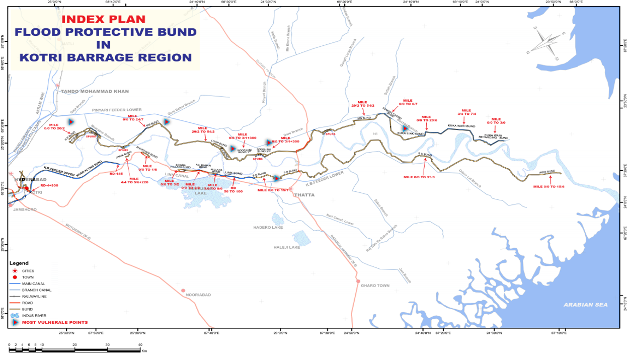
Salient Features of Bunds |
|||||
| S/N | District | Name of Main Bund | 1st Line | Name of Loop Bund | 2nd Line |
|---|---|---|---|---|---|
| KALRI BAGHAR DIVISION THATTA | |||||
| 1 | Thatta | Left Bank K.B Feeder Upper RD 4 to 135 (Acting River Bund) | 26-0 | Sonda Loop, Behind S.H. Bund, mile 0/0 to 1/6. | 1-6 |
| 2 | Thatta | Jherruck Bund Mile 0/0 to 5/6+220. | 5-6+220 | Sonda Loop No.1, Behind S.H. Bund, mile 1/2 to 3/0. | 1-7 |
| 3 | Thatta | Shaikhani Bund Mile 0/0 to 1/6. | 1-6 | Sonda Loop No.2 Behind S.H Bund, Mile 2/6 to 3/2. | 0-4 |
| 4 | Thatta | Sonda Hillaya Bund Mile 0/0 to 3/2 | 3-2 | Hillaya Loop Behind S.H Bund, mile 7/0 to 7/5. | 0-6 |
| 5 | Thatta | Ali Bahar Bund Mile 0/0 to 2/2 | 2-2 | Link Canal Loop Bund from RD 56 to 65 | 1-7 |
| 6 | Thatta | Sonda Hillaya Bund Mile 7/0 to 8/6 | 1-6 | Retarded Mangli Behind B.U Bund, Mile 15/3 to 16/3. | 1-1 |
| 7 | Thatta | Link Bund from RD 56 to 100 | 8-4 | Delaying action Mangli with Trench Below B.U. Bund, mile 33/4 to 34/1. | 0-3 |
| 8 | Thatta | Panna Baghar Bund mile 0/0 to 15/1 | 15-1 | Orderolal Loop Bund Behind B.U Bund, mile 24/0 to 0/4 of Indo Bund. | 2-0 |
| 9 | Thatta | Baghar Uchito Bund Mile 0/0 to 10/0 | 10-0 | - | |
| Total K.B. Thatta: | 74-3+22 | 10-2 | |||
| SAKRO DIVISION MIRPUR SAKRO | |||||
| Thatta | Baghar Uchito Bund Mile 10/0 to 35/3 | 25-3 | - | ||
| 10 | Thatta | Indo Bund Mile 0/0 to 15/6 | 15-6 | - | |
| Total Sakro Division: | 41-1 | - | |||
| Grand Total Baghar Circle: | 115-4 | 10-2 | |||

Salient Features of Bunds |
||||||
| S/N | District | Name of Main Bund | 1st Line | Name of Loop Bund | 2nd Line | Spurs |
|---|---|---|---|---|---|---|
| UPPER PINYARI DIVISION HYDERABAD | ||||||
| 1 | T.M.Khan | Hajipur Bund Mile 0/0 to 20/2 | 20-2 | 1st Mile Loop Bund Mile 0/0 to 2/6. | 2-6 | 4 Nos Spurs. (2 T Spurs and J Spurs) 07 Nos Studs |
| 2 | T.M.Khan | - | Jones Wah Cross Bund Mile 0/0 to 0/6. | 0-6 | ||
| 3 | T.M.Khan | - | Wasi Loop Bund Mile 0/0 to 1/6. | 1-6 | ||
| 4 | T.M.Khan | - | Wasi Cross Bund Mile 0/0 to 0/6. | 0-6 | ||
| 5 | T.M.Khan | - | Wasing Wah Bund Mile 0/0 to 0/6. | 0-6 | ||
| 6 | T.M.Khan | - | Katiar Loop Bund Mile 0/0 to 3/1. | 3-1 | ||
| 7 | T.M.Khan | - | Miranpur Loop Bund Mile 0/0 to 1/3 | 1-3 | ||
| 8 | T.M.Khan | - | 8th Mile Loop Bund Mile 0/0 to 2/2. | 2-0 | ||
| 9 | T.M.Khan | - | 12th Mile Loop Bund Mile 0/0 to 5/1. | 5-1 | ||
| 10 | T.M.Khan | - | Budhka Cross Bund Mile 0/0 to 0/6. | 0-6 | ||
| 11 | Sujawal | M.S Bund Mile 0/0 to 24/7 | 24-7 | 2nd Kot Almo Bund Mile 0/0 to 3/2. | 3-2 | |
| 12 | Sujawal | Bano Wakri Bund Mile 0/0 to 1/5. | 1-5 | |||
| 12 | Sujawal | Ranto Loop Bund Mile 0/0 to 2/3. | 0-7 | |||
| 13 | Sujawal | New Loop Bund Mile 0/0 to 2/3. | 2-3 | |||
| Total UPD: | 45-1 | 26-4 | ||||
| LOWER PINYARI DIVISION SUJAWAL | ||||||
| 15 | Sujawal | 1st Surjani Bund Mile 0/0 to 3/1+300 | 3-1+300 | - | - | 05 Nos. |
| 16 | Sujawal | 2nd Surjani Bund Mile 0/0 to 1/5 | 1-5 | - | - | - |
| 17 | Sujawal | M.S Bund Mile 29/2 to 58/2. | 29-0 | - | - | - |
| 18 | Sujawal | Gungri Chord Bund Mile 0/0 to 0/7. | 0-7 | - | - | - |
| 19 | Sujawal | Kuka Link Bund Mile 0/0 to 20/6. | 20-6 | - | - | - |
| 19 | Sujawal | Kuka Wari Bund Mile 3/4 to 7/4. | 4-0 | - | - | - |
| 19 | Sujawal | Kuka Wari Retarding Bund Mile 0/0 to 3/0 | 3-0 | - | - | - |
| Total LPD: | 62-3+300 | 26-4 | 05 Nos. | |||
| Grand Total Baghar Circle: | 107-4+300 | 26-4 | 09 Nos. | |||

Salient Features of Bunds |
|||||||||
|---|---|---|---|---|---|---|---|---|---|
| S.No. | Name of Bunds | Top Width | D.H.F.L | Top RLS | Ground RLS | Slide Slope | Length | ||
| (ft) | (Land Face) | (River Face) | (ft) | ||||||
| 1 | U/S Left Guide Bund | 30 | 80.5 | 84.5 | 60.5 | 3:01 | 2:01 | 5700 | |
| 2 | D/S Left Guide Bund | 30 | 79.5 | 83.5 | 68 | 3:01 | 2:01 | 900 | |
| 3 | U/S Right Guide Bund | 30 | 80.5 | 84.5 | 60 | 3:01 | 2:01 | 5700 | |
| 4 | D/S Right Guide Bund | 30 | 79.5 | 83.5 | 74 | 3:01 | 2:01 | 1100 | |
| 5 | U/S Left Marginal Bund | 30 | 80.5 | 84.5 | 67 | 2:01 | 2:01 | 2800 | |
| 6 | D/S Left Marginal Bund | 40 | 81.5 | 85.5 | 67.5 | 2:01 | 2:01 | 4080 | |
| 7 | U/S Right Marginal Bund | 30 | 80.5 | 84.5 | 65.0 to 72.0 | 3:01 | 2:01 | 8400 | |
| 8 | D/S Right Marginal Bund | 30 | 79.5 | 83.5 | 62.2 to 71.6 | 3:01 | 2:01 | 4800 | |
| Total | 33480 ft 5000 |
||||||||
4 Main Components
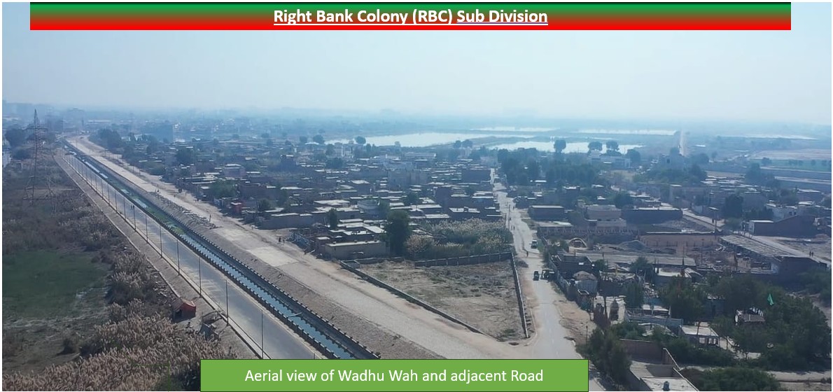
1. Wadhu Wah:- is artificial canal originating from the Right Bank of the Combined Channel at RD 3+800. Originally constructed to irrigate the agricultural lands of Qasimabad and Latifabad - long before these areas were transformed into urban settlements—the canal was designed with a capacity of 30 cusecs and a length of 23+500 up to G.O.R. Colony. In earlier times, its total length extended beyond 40 RDs, reaching Fateh Chowk.
Over the years, its function evolved: first converted from irrigation purpose to supply drinking water to towns, and eventually reduced to serving as a drainage channel for the towns, carrying sewerage instead of fresh water. Presently, under the PC Rehabilitation of Wadhu Wah and Fasadi Wah, the canal is being rehabilitated and restored to its intended purpose, marking an important step in reviving this historic
2. Fasadi Wah:- is also an artificial canal deriving from 7 Rd of Wadhu Wah from its right bank and used for irrigation purpose. Its Length is 9+200 ft and has a discharge capacity of 15 cusecs.
3. RBB Colony:-:- is a colony situated in Jamshoro for irrigation employees. It’s water supply, Drainage and Road Network is maintained and controlled by RBC sub-division.
4. Water Supply & Drainage:- AEN RBC to ensure The water supply & Drainage for RBB colony Jamshoro and Officers Housing colony.
Kotri Barrage Region
| Downloads | |
| Google Earth KML/KMZ | |
| Kotri Barrage Canal Network | |
| Kotri Barrage Bunds | |
| Wadhu Wah / Fasadi | |
| Keenjhar Lake | |
| Channel Operational Manual | |
| Channel operation & maintenance manual Vol1 | Channel operation & maintenance manual CH 1-4 |
| Channel operation & maintenance manual CH 5 | National Water Policy |
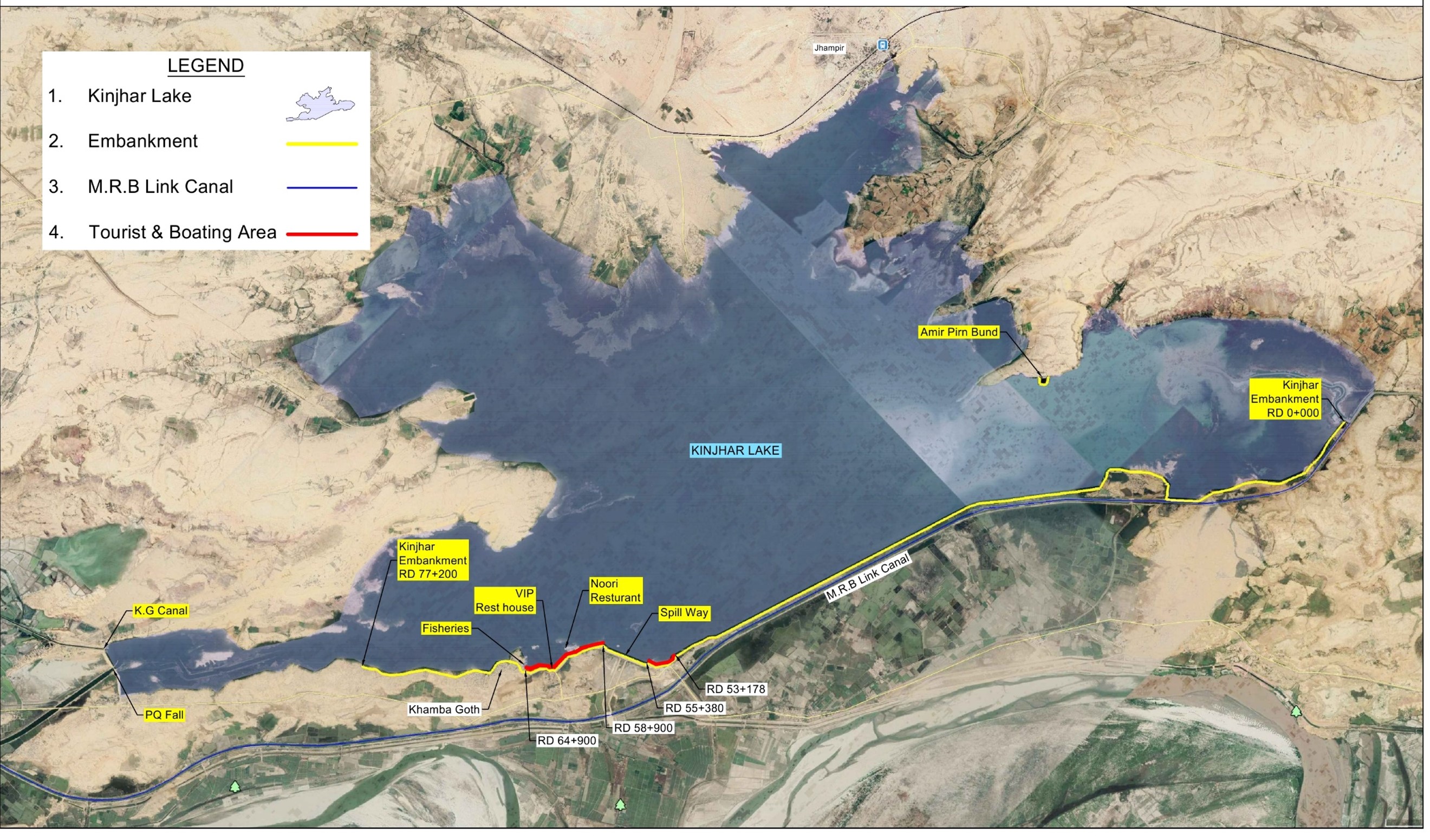
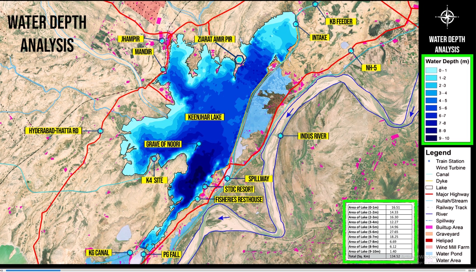
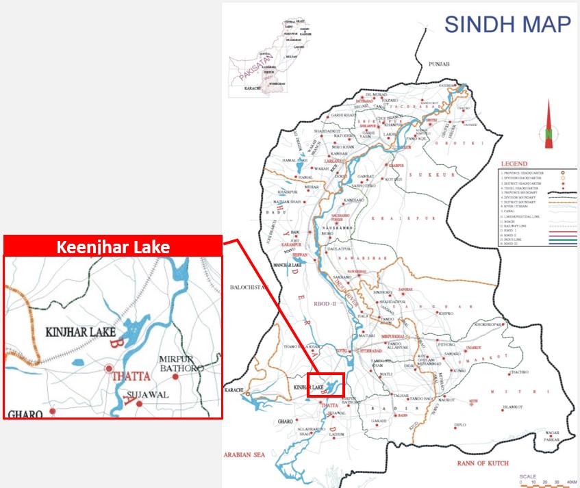
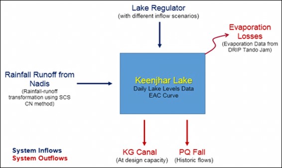
Introduction : Keenjher Lake, also known as Kalri Lake, is situated approximately 22 kilometers away from Thatta, 122 kilometers from Karachi, and 80 kilometers from Hyderabad. This lake is artificially created and is fed by the Kalri-Baghar Feeder Upper, sourced from the Right Bank of Kotri Barrage. Covering an area of 52.00 square miles at various water levels, Keenjhar Lake was formed by constructing earthen embankments with a length of 77 RD and a height of 25 feet, utilizing natural depressions like Sonheri and Keenjhar.
The main purpose of this artificial reservoir is to ensure a reliable water supply for domestic and industrial use in Karachi, accounting for approximately 80% of the city's total requirement. The Irrigation and Power Department provides 1200 cusecs of silt-free water through the Keenjhar-Gujjo canal from Keenjhar Lake, with the canal having a discharge capacity of 1382 cusecs.
| Area of Lake at R.L 54.0 | 52.00 Sq. miles |
| Gross storage capacity |
0.558 MAF Before Project
0.660 MAF After Project(RL 57) |
| Live storage capacity | 0.38 MAF |
| Average depth of water | 20 Ft |
| Maximum height of embankments | 34.00 Ft |
| Length of embankments | 15.00 Miles |
| Deposition of silt per year | 4335 Ac.ft |
| Original Design Life | 132 Years |
| Reduction of life after siltation | 87 Years |
| Life after construction of Link Canal by passing Keenjhar Lake | 192 Years |
| Elevation (Ft) | Area (Sq. Miles) | Volume (MAF) |
|---|---|---|
| 30 | 11.01 | 0.029 |
| 32 | 17.39 | 0.047 |
| 34 | 23.68 | 0.073 |
| 36 | 26.8 | 0.106 |
| 38 | 29.3 | 0.142 |
| 40 | 31.68 | 0.181 |
| 42 | 34.59 | 0.223 |
| 44 | 37.69 | 0.27 |
| 46 | 40.86 | 0.32 |
| 48 | 44.25 | 0.374 |
| 50 | 46.63 | 0.433 |
| 52 | 48.91 | 0.494 |
| 54 | 51.29 | 0.558 |
| 56 | 53.72 | 0.625 |
| 57 | 54.83 | 0.66 |
| SALIENT FEATURES OF KALRI BAGHAR FEEDER UPPER | |
|---|---|
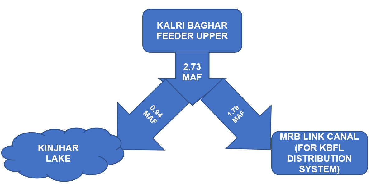
| The main feeding source of the Lake is Kalri-Baghar Feeder (upper) which off- takes from right bank of Kotri Barrage . | |
| Design Discharge | 9100 Cusecs |
| Full Supply Level | 67.0 Ft |
| Full Supply Depth | 15.0 Ft |
| Design Bed Level | 52.0 Ft |
| Design Bed Width | 195 Ft |
| Nos. of Span | 6.0 Nos. |
| Width of Span | 24.0 Ft |
| CCA | 603000 Acres |
| Length of Canal | 38.0 Miles |
| Cutoff | 13.80 Ft |
| Pavement Level | 52.0 Ft |
| Cill level | 56.0 Ft |
Karachi Water & Sewerage Board (KW & SB) initiated different projects time to time in order to meet out the present and future demand.
| Project Name | Discharge (Cs) | Cumulative Discharge (Cs) |
|---|---|---|
| K-I | 520 | 520 |
| K-II | 380 | 900 |
| K-III | 300 | 1200 |
| K-IV | 1200 |
2400
( under process) |
| A. Computation | |
|---|---|
| Before the Project | |
| I) Computation at RL 54.0 ft. | |
| Area of water in Lake sq miles | = 51.29 sq. miles - (Area Capacity Curve) |
| Volume of water Lake MAF | = 0.558 M.A.F - (Area Capacity Curve) |
| = 558000 A.F | |
| After the Project | |
| II) Computation at RL 57.0 ft. | |
| Area of water in Lake sq miles | = 54.83 sq. miles- (Area Capacity Curve) |
| Volume of water Lake MAF | = 0.66 M.A.F - (Area Capacity Curve) |
| = 660000 A.F | |
| B. Additional Water Availability after the Project | |
| Total Additional Water Availability for a period of year | = 660000 – 558000 |
| = 102000 Acre ft. | |
| Additional Water Available per period for a period of one year | = 102000/ (1.98* 365) |
| in cusecs | = 141.14 ft3/sec |
| Thus, Quantity of Additional Water Availability for six months | = 141.14*2 = 282.28 cusecs |
| Thus, Quantity of Additional Water Availability for four months | = 141.14*3 = 423.42 cusecs |
| Critical period of four months i.e. from November to February in which water supplied to Keenjhar Lake from Upper K.B Feeder is reduced, during this period; a quantity of 423 cusecs will increase the supply of K.B Feeder for supply to Karachi for a period of 120 days. Presently KW&SB is drawing un-interrupted water supply of 900 cusecs daily through Keenjhar-Gujjo Canal. Therefore if additional quantity of 423 cusecs is made available then it will meet with the present demand of water supply for Karachi i.e. 1200 cusecs as envisaged by KW&SB in their K-3 project. | |
Inflow from Kalri Baghar Feeder Upper (KBFU) to Keenjhar = 0.94 MAF
| Rainfall contributions from Hill torrents approximately 50,000 acre- ft has been estimated from the nullahs draining into the Lake | = 0.05 MAF |
| Direct Rainfall on Keenjhar lake having Area(33280 acres) | = 0.033 MAF |
| Total Inflow in MAF= 0.94+0.05+0.033= 1.02 MAF | |
| In Kharif Season | |
| Total Outflow 825 MGD = KG Canal (600 MGD) and PQ Fall (225 MGD) | = 0.554 MAF |
| In Rabi Season (6 Month) | |
| Total Outflow 600 MGD = KG Canal (460 MGD) and PQ Fall (140 MGD) | = 0.400 MAF |
| Total Losses at the Rate of 7 % | = 0.0726 MAF |
| Total Outflow = Kharif Season + Rabi Season + Losses | |
| =0.554 + 0.400+ 0.0726 = 1.02 MAF | |
| In Kharif Season | |
| Total Outflow/Demand 1085 MGD = KG Canal (885 MGD) and PQ Fall (225 MGD) | = 0.729 MAF |
| In Rabi Season (6 Month) | |
| Total Outflow/Demand 910 MGD = KG Canal (720 MGD) and PQ Fall (190 MGD) | = 0.608 MAF |
| Total Losses at the Rate of 7 % | = 0.0826 MAF |
| Total Outflow = Kharif Season + Rabi Season + Losses | |
| 0.729 + 0.608+ 0.0826 = 1.42 MAF | |
| Reservoir Storage = 0. 80 MAF | |
| Total = 2.22 MAF | |
Kotri Barrage is situated 3 miles North of Hyderabad City. The project was sanctioned a few months before the dawn of independence in 1947. The Head works, were completed in 1955, and the left bank no perennial canals received weir controlled supplies the same year while Akram wah (Perennial) was made operational in 1958. On the Right Bank one single canal, Kalri Bagar Feeder off takes and it started functioning for first time in year 1958.
Four feeder canals, three on the left and one on the right bank of River Indus off-take from this Barrage and deliver assured Irrigation Water supplies for an area of 3.0 million acres. The feeder on the right, namely, Kalri Bagar Feeder has a unique designed where the Keenjhar Lake forms the integral Part of the canal system.
Kotri Barrage is situated 3 miles North of Hyderabad City. The project was sanctioned a few months before the dawn of independence in 1947. The Head works, were completed in 1955, and the left bank no perennial canals received weir controlled supplies the same year while Akram wah (Perennial) was made operational in 1958. On the Right Bank one single canal, Kalri Bagar Feeder off takes and it started functioning for first time in year 1958.
| S# | Date | Kotri Barrage | Off taking Channels Position | |||||||||||||||
|---|---|---|---|---|---|---|---|---|---|---|---|---|---|---|---|---|---|---|
| U/S Q | D/S Q | Actual W.D | As per 1991 Accord 10 daily W.D |
%
(-) Shortage/ (+) Increase |
Kalri Begar Feeder | Akram Wah | Old Phuleli / Pinyari | New Phuleli | ||||||||||
| Actual Q |
As per 1991 Accord
10 daily W.D |
%
(-) Shortage/ (+) Increase |
Actual Q |
As per 1991 Accord
10 daily W.D |
%
(-) Shortage/ (+) Increase |
Actual Q |
As per 1991 Accord
10 daily W.D |
%
(-) Shortage/ (+) Increase |
Actual Q |
As per 1991 Accord
10 daily W.D |
%
(-) Shortage/ (+) Increase |
|||||||


